Home
 In
his book "Ring of Bright Water" the author Gavin Maxwell wrote of his home at Sandaig (5 miles south of Glenelg) "That neither the house nor its islands and lighthouse are
visible from the road above, and that paradise within a paradise
remains, to the casual road-user unguessed".
In
his book "Ring of Bright Water" the author Gavin Maxwell wrote of his home at Sandaig (5 miles south of Glenelg) "That neither the house nor its islands and lighthouse are
visible from the road above, and that paradise within a paradise
remains, to the casual road-user unguessed".
Today,
that sentence could easily be applied to Glenelg itself. Many
who come down the Glen Shiel road towards Kintail are unaware
of the community of Glenelg, which lies at the other side of the
Mam Ratigan. Those who do turn off at Shiel Bridge, are transported
back in time, as they encounter the single track road with its
![]() passing
places, that winds its way over the Mam to Glenelg. On the way
up there are reminders of the original narrow twisting road with
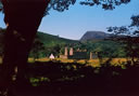
its stone arch bridges. On reaching the summit at 1116ft, you
can look back down towards Kintail and up towards the famous "five
sisters" of Kintail; a range of 3000ft plus mountains that
tower over the Glen Shiel road. The travel writer H. V. Morton
described this view; "Of all the great views I
passing
places, that winds its way over the Mam to Glenelg. On the way
up there are reminders of the original narrow twisting road with
its stone arch bridges. On reaching the summit at 1116ft, you
can look back down towards Kintail and up towards the famous "five
sisters" of Kintail; a range of 3000ft plus mountains that
tower over the Glen Shiel road. The travel writer H. V. Morton
described this view; "Of all the great views I know in Scotland this is the one that I place for its grandeur,
its magic beauty, its terrifying splendour...The view from Mam
Rattachan is a scene a man could watch with the same reverence
and love every day of his life."
know in Scotland this is the one that I place for its grandeur,
its magic beauty, its terrifying splendour...The view from Mam
Rattachan is a scene a man could watch with the same reverence
and love every day of his life."
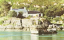
The
descent from the Mam is winding with a steep drop on the left-hand
side. In the distance you can just make out the waters of the
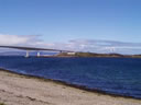
Sound of Sleat. As you approach the village of Glenelg you come
to a fork in the road, the right hand leads to the ferry, the
traditional crossing point  to
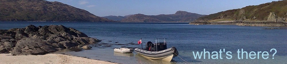
the Island of Skye, passing Glenelg beach with its uninterrupted
views down the Sound of Sleat to the islands of Rhum, Eigg and
Muck. The ferry (the last hand-operated turntable in the world!)
is the only other way for vehicles to get to Glenelg but it only
operates between April and September. Continuing on the road towards
Glenelg, down the tree lined avenue you will see on the right
an imposing four storey ruined
to
the Island of Skye, passing Glenelg beach with its uninterrupted
views down the Sound of Sleat to the islands of Rhum, Eigg and
Muck. The ferry (the last hand-operated turntable in the world!)
is the only other way for vehicles to get to Glenelg but it only
operates between April and September. Continuing on the road towards
Glenelg, down the tree lined avenue you will see on the right
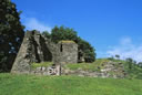
an imposing four storey ruined![]() building, The Barracks at Bernera were built in the 1700's to
control the crossing at Kylerhea and suppress any uprising by
the native population.
building, The Barracks at Bernera were built in the 1700's to
control the crossing at Kylerhea and suppress any uprising by
the native population.
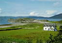
Glenelg
itself is a collection of dwellings with one main street, where
you'll find a shop and at the far end, the Glenelg Inn. Past the
entrance to the Inn is the Church and through a blind corner you
come upon the  Monument.
An impressive tribute to those who fell in the First World War.
It stands overlooking where the harbour would have been. There
are panoramic views from the monument up towards Kylerhea, across
to Skye and down towards the Point of Sleat. The road passes a
collection of houses before crossing the bridge at the entrance
to Glen Beag. Those who venture up Glen Beag will come across
the Brochs, two
Monument.
An impressive tribute to those who fell in the First World War.
It stands overlooking where the harbour would have been. There
are panoramic views from the monument up towards Kylerhea, across
to Skye and down towards the Point of Sleat. The road passes a
collection of houses before crossing the bridge at the entrance
to Glen Beag. Those who venture up Glen Beag will come across
the Brochs, two examples (the best on the Scottish mainland) of fortified round
houses, which were built 4000 years ago.
examples (the best on the Scottish mainland) of fortified round
houses, which were built 4000 years ago.
Crossing
the bridge the single-track road winds down towards the village
of Arnisdale, passing the unmarked track that leads to Sandaig.
Arnisdale  lies
at the foot of Beinn Sgritheal, a three thousand-foot mountain
that rises vertically from the sea to dominate the landscape.
Across the dark waters of Loch Hourn (the loch of Hell in Gaelic,
Loch Nevis the Loch of Heaven is nearby) is Knoydart. This mountainous
terrain is considered by many to be the last great wilderness
in Europe. The road ends at Corran but you can continue by foot
on the old drovers track, which leads from the Kylerhea ferry
across the shoulder of Beinn Sgritheall and down the loch towards Kinloch Hourn and
the south.
lies
at the foot of Beinn Sgritheal, a three thousand-foot mountain
that rises vertically from the sea to dominate the landscape.
Across the dark waters of Loch Hourn (the loch of Hell in Gaelic,
Loch Nevis the Loch of Heaven is nearby) is Knoydart. This mountainous
terrain is considered by many to be the last great wilderness
in Europe. The road ends at Corran but you can continue by foot
on the old drovers track, which leads from the Kylerhea ferry
across the shoulder of Beinn Sgritheall and down the loch towards Kinloch Hourn and
the south.
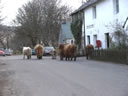
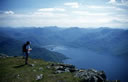
Glenelg is the ideal base to explore the North Western Highlands
and the ![]() Island of Skye. Throughout this area, there is an abundance of
wildlife (from Highland Cows to Golden Eagles) and plenty of walks
from the shoreline to three thousand foot plus.
Island of Skye. Throughout this area, there is an abundance of
wildlife (from Highland Cows to Golden Eagles) and plenty of walks
from the shoreline to three thousand foot plus.
This "unguessed" paradise awaits you....